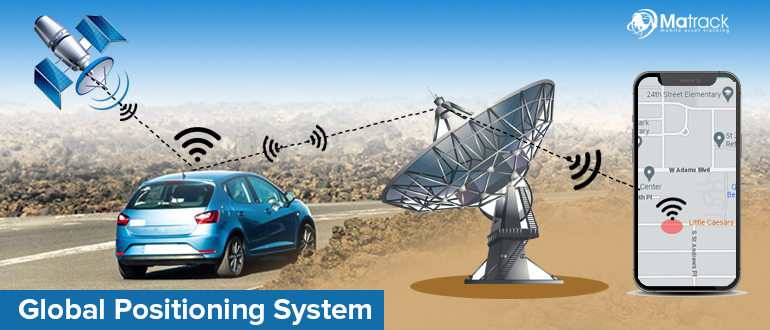
What Is a Global Positioning System?
The Global Positioning System (GPS) is a satellite-based navigation system that provides location, navigation, and timing data anywhere on Earth in all weather conditions. Signals transmitted from orbiting satellites allow receivers to determine position using a method called trilateration.
GPS enables devices to identify their location by connecting with multiple satellites at the same time. Smartphones, vehicles, and tracking systems use this capability to display real-time position with high accuracy.
Reliable positioning has made GPS essential for modern technology and daily operations. Navigation apps, aviation systems, and emergency services depend on continuous satellite signals to maintain accurate tracking.
History of GPS
GPS history began in the late 1950s and 1960s, when scientists found that satellite radio signals could help determine location. Early systems like the U.S. Navy’s Transit program proved that satellites could be used for navigation and created a foundation for future development.
Major progress started in 1973, as the U.S. Department of Defense launched the NAVSTAR GPS program to build a global navigation system. Satellites were gradually deployed throughout the late 1970s and 1980s, forming a network designed for continuous worldwide coverage.
Use of GPS increased during the 1980s and 1990s across aviation, mapping, and transportation systems. Full operational capability was reached in 1995, and accuracy improved significantly in 2000 after Selective Availability was removed.
How Does GPS Work?
GPS works by measuring distances from multiple satellites and combining them to calculate an exact position.
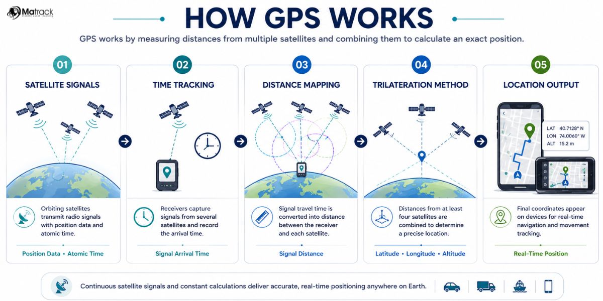
- Satellite Signals: Orbiting satellites continuously transmit radio signals that include position data and precise time from atomic clocks. Signals travel toward receivers at the speed of light.
- Time Tracking: Receivers capture signals from several satellites and record the arrival time for each one. The difference between transmission time and reception time reveals how far the signal has traveled.
- Distance Mapping: Signal travel time is converted into distance between the receiver and each satellite. Multiple distance values create reference points needed for positioning.
- Trilateration Method: Distances from at least four satellites are combined using trilateration to determine a precise location in three dimensions. Latitude, longitude, and altitude are calculated through this process.
- Location Output: Final coordinates appear on devices like smartphones, vehicle systems, and tracking tools. Continuous updates allow real-time navigation and movement tracking.
What Are the Main Components of a GPS System?
GPS operates through three interconnected segments that enable continuous positioning, navigation, and timing across the globe.
1. Space Segment (GPS Satellites)
A network of satellites orbits Earth in Medium Earth Orbit (MEO), forming a constellation that ensures global coverage. Signals transmitted from these satellites carry precise timing and orbital data, allowing receivers to determine their position accurately.
2. Control Segment (Ground Stations)
Ground infrastructure monitors satellite health, tracks orbital paths, and maintains synchronization across the system. Data collected from monitoring stations is processed by a master control station, which updates satellite information and corrects timing errors.
3. User Segment (GPS Receivers)
Devices such as smartphones, vehicle navigation systems, and tracking units receive satellite signals and convert them into usable location data. Processing within the receiver calculates position, speed, and time, enabling real-time navigation and tracking.
What Is Trilateration?
Trilateration is the method used in GPS to determine location using distance measurements from multiple satellites. Time-stamped data transmitted from satellites allows receivers to calculate how far away each satellite is.
At least four satellites are required to resolve location and timing differences accurately. Distances from multiple reference points intersect to form a single coordinate, defining latitude, longitude, and altitude.
Reliable location tracking depends on how precisely these distance calculations are combined. Trilateration enables GPS to deliver consistent real-time coordinates, supporting navigation, mapping, and tracking across various environments.
What Is Geofencing?
Geofencing is a location-based technology that creates virtual boundaries around real-world areas using GPS, Wi-Fi, RFID, or cellular networks. Entry or exit from these boundaries triggers predefined actions such as alerts, app notifications, or automated system responses.
Boundaries are defined using digital mapping tools, where coordinates, radius distances, or polygon shapes are set around a specific location. Tracking systems continuously compare device location data against these boundaries using real-time positioning and backend processing.
Crossing a geofence activates event-based triggers configured through software platforms or APIs. Applications range from fleet tracking and security monitoring to targeted marketing and workforce management, where location-based automation improves control and operational efficiency.
How Accurate Is GPS and What Affects Its Accuracy?
GPS accuracy generally ranges between 3 to 10 meters under open-sky conditions, though several factors can influence precision.
- Atmospheric Effects: Signal delay occurs as radio waves pass through the ionosphere and troposphere. Variations in atmospheric conditions can slightly distort distance calculations.
- Signal Obstruction: Buildings, trees, and terrain can block or weaken satellite signals before they reach the receiver. Limited visibility reduces the number of satellites available for accurate positioning.
- Multipath Errors: Reflected signals from surfaces like walls or water create multiple signal paths. Interference from these reflections can lead to incorrect distance measurements.
- Satellite Geometry: Position of satellites relative to the receiver affects calculation accuracy. Poor alignment can reduce precision even with multiple signals.
- Receiver Quality: Hardware capability and internal processing determine how accurately signals are interpreted. High-quality receivers provide better accuracy and faster calculations.
- Correction Systems: Technologies like Assisted GPS (A-GPS) and Differential GPS (DGPS) improve accuracy. External data sources help reduce timing errors and enhance positioning reliability.
What Is the Difference Between GPS and GNSS?
GPS is a specific satellite navigation system, while GNSS is the global network that includes multiple satellite systems providing positioning, navigation, and timing data.
| GPS (Global Positioning System) | GNSS (Global Navigation Satellite System) |
| Satellite navigation system operating through its own constellation | Collective term covering all global satellite navigation systems |
| Only GPS satellites | GPS, GLONASS, Galileo, BeiDou |
| Global coverage through dedicated satellites | Wider coverage using multiple constellations |
| High accuracy, typically within 3–10 meters | Improved accuracy due to combined signals |
| Depends on single satellite system | Higher reliability with multiple systems available |
| Performance may drop in obstructed areas | Better signal access in dense or urban environments |
| Used in standalone navigation devices | Used in modern multi-constellation receivers |
What Are the Common Uses of GPS Today?
Accurate location tracking and real-time navigation support a wide range of applications across industries and everyday use.
Personal Navigation
Smartphones and vehicle navigation systems use GPS to provide turn-by-turn directions and route optimization. Travel time, traffic conditions, and alternate routes are calculated dynamically for efficient movement.
Fleet Tracking
Logistics and transportation systems rely on GPS to monitor vehicle location, routes, and driver activity. Real-time visibility helps improve fuel efficiency, delivery accuracy, and operational control.
Aviation Systems
Aircraft navigation depends on GPS for route guidance, altitude tracking, and flight path management. Integration with onboard systems enhances safety and precision during travel.
Maritime Navigation
Ships and vessels use GPS to determine direction, distance, and current location across open water. Accurate positioning supports route planning and collision avoidance.
Emergency Services
Police, ambulance, and rescue teams use GPS to locate incidents and reach destinations quickly. Faster response times improve coordination and effectiveness during critical situations.
Agriculture Technology
Precision farming uses GPS for field mapping, equipment guidance, and crop monitoring. Data-driven decisions help optimize resource usage and improve productivity.
Why Is GPS Important in Modern Technology?
Precise location data and synchronized timing enable modern systems to operate efficiently across transportation, communication, and infrastructure networks.
Real-Time Navigation
Transportation systems rely on continuous location updates to guide movement across roads, airspace, and waterways. Route optimization, traffic management, and travel efficiency depend on accurate positioning.
Logistics Efficiency
Supply chains use location tracking to monitor shipments, reduce delays, and improve delivery accuracy. Better visibility into movement helps businesses control costs and optimize operations.
Safety and Emergency Response
Emergency services depend on accurate location data to respond quickly to incidents. Faster identification of locations improves rescue coordination and reduces response time.
Infrastructure and Connectivity
Telecommunication networks rely on precise timing signals from satellites to synchronize data transmission. Financial systems, power grids, and communication networks depend on this timing for stable operation.
IoT and Smart Systems
Connected devices use location data to automate processes and enable intelligent decision-making. Applications in smart cities, asset tracking, and automation rely on continuous positioning input.
Why Choose Matrack for Fleet Tracking?
Matrack GPS fleet tracking provides real-time fleet visibility through live location tracking, geofencing, and instant alerts that keep operations connected at all times. Fleet managers can monitor movement, respond quickly to issues, and maintain control across small to enterprise-level fleets.
Route planning and dispatching improve with built-in tools that use GPS data to optimize routes and deliver accurate ETAs. Integrated ELD reporting, driver monitoring, and real-time updates help reduce delays while keeping operations compliant without added complexity.
Operational costs are reduced through AI-based fuel optimization and detailed reporting that highlight inefficiencies. No long-term contracts, easy installation, and continuous support make the system flexible and practical for growing fleet operations.
Frequently Asked Questions
How does GPS maintain accuracy in dense urban areas with signal obstruction?
Accuracy improves in cities through the use of multiple satellite systems and assisted technologies like A-GPS. Extra data sources help reduce errors caused by tall buildings and reflected paths.
What role do atomic clocks play in GPS signal timing and synchronization?
Atomic clocks keep extremely precise time, which allows devices to calculate distance accurately. Even a tiny mismatch in timing can lead to noticeable location errors.
Can GPS function effectively without access to multiple satellite systems like GNSS?
GPS can work on its own using its satellite network to provide global location data. Performance becomes more stable and precise when other systems are available alongside it.
How do environmental factors like weather and terrain impact GPS performance over time?
Weather conditions and physical surroundings can slightly affect how accurately location is calculated. Obstacles like mountains, dense forests, or buildings may reduce visibility to satellites.
What advancements are being made to improve GPS accuracy and reliability in the future?
New satellite upgrades and multi-frequency technology are making location data more precise. Ongoing improvements in processing and correction methods continue to strengthen reliability.
