What Is a Geographic Information System?
Geographic Information System (GIS) is a system that stores and organizes information connected to specific locations. Maps, land records, infrastructure data, boundaries, and environmental features can all be brought into one geographic view.
Place-based information becomes more meaningful as it connects to real locations rather than existing as isolated records. GIS provides geographic context to data tied to roads, buildings, utilities, parcels, and natural areas.
Urban planning, public works, environmental management, and site analysis often depend on geographic information systems. Geographic context helps institutions examine places with more precision in real operating conditions.
What Is the History of GIS?
History of GIS began in 1963 as Roger Tomlinson developed the Canada Geographic Information System. Work laid the foundation for combining land use data with mapped locations to support automated land inventory and resource planning.
Earlier forms of spatial mapping appeared long before formal GIS systems emerged. Charles Picquet created a cholera map of Paris in 1832, and John Snow mapped cholera deaths in London in 1854 to trace the outbreak to a single water pump.
Major advances arrived during the 1980s and 1990s, when GIS developed into desktop software through platforms such as ArcInfo, GRASS GIS, and MapInfo. Cloud-based platforms, mobile GIS applications, and open-source tools later expanded GIS access and functionality across industries during the 2010s.
Why Is GIS Important?
Location plays a critical role in how decisions are made across planning, operations, and resource management. Geographic context allows data to be examined in relation to real-world conditions rather than as isolated records.
Organizations rely on GIS to identify patterns across land use, infrastructure, population distribution, and environmental conditions. Spatial relationships between features, assets, and boundaries help improve accuracy in planning and analysis.
Public agencies and infrastructure teams also depend on geospatial systems for measurable operational value. The U.S. Geological Survey says conservative estimates put benefits from its 3D Elevation Program at $690 million per year, showing how geographic data supports decisions tied to safety, property, and the environment.
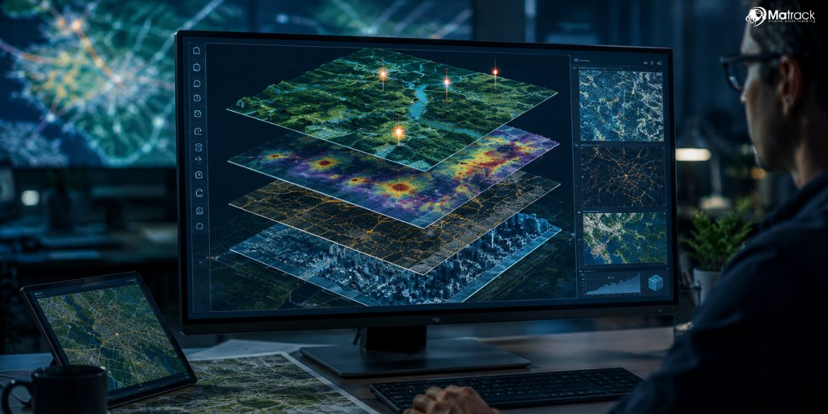
How Does GIS Work?
Geographic Information System works by linking location-based records with mapped places so geographic relationships can be examined in context.
- Data Input: GIS collects information from sources such as surveys, satellite imagery, GPS, field observations, and existing geographic databases.
- Map Features: Locations are represented through points, lines, polygons, boundaries, and other mapped elements tied to real places.
- Layer Setup: Different datasets such as roads, land parcels, utilities, terrain, and land use are arranged as separate geographic layers.
- Record Linking: Spatial features are connected with related details such as names, measurements, categories, ownership, or site conditions.
- Spatial Analysis: Geographic relationships between features, distances, boundaries, and nearby areas are examined to identify patterns and interactions.
- Visual Output: Results are presented through maps, layouts, and geographic views that help users interpret place-based information.
What Are the Main Components of a Geographic Information System?
A GIS operates through several core components that support mapping, analysis, storage, and management of location-based information.
Hardware Systems
Hardware includes computers, servers, GPS devices, drones, tablets, and field equipment used for data collection and processing. High-capacity systems support map rendering, field surveys, and large-scale geographic workflows.
Software Platforms
Software supports mapping, spatial analysis, database management, and visualization. Platforms such as ArcGIS and QGIS help users manage layers, edit datasets, and produce geographic outputs for planning and research.
Geographic Data
Geographic data includes spatial data and attribute data linked to roads, parcels, utilities, terrain, land use, and environmental features. Vector data, raster data, satellite imagery, survey records, and remote sensing inputs all contribute to geographic analysis.
People Roles
People involved in GIS include analysts, planners, engineers, cartographers, survey teams, and decision-makers. Professional roles cover data collection, map interpretation, quality control, and geographic reporting across real operating environments.
Operational Methods
Methods define standards for collection, validation, storage, updating, and long-term maintenance of geographic records. Coordinate systems, metadata, accuracy checks, and workflow rules help keep GIS outputs reliable and usable.
What Types of Data Does GIS Use?
Different types of geographic data allow maps to represent features, surfaces, boundaries, and real-world conditions across space.
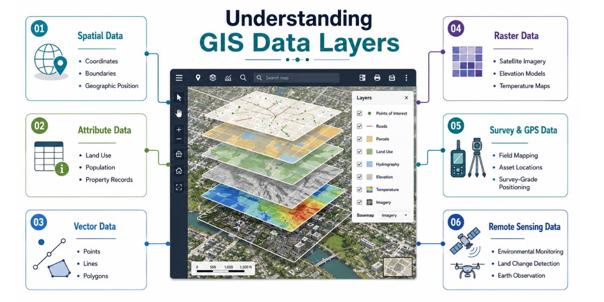
Spatial Data
Spatial data shows where something is located on a map. Coordinates, boundaries, shapes, and positions allow roads, buildings, rivers, parcels, and other features to be placed in geographic space.
Attribute Data
Attribute data gives descriptive details about a mapped feature. Names, land use class, ownership records, population figures, pipe size, road type, and site condition all fall under attribute information.
Vector Data
Vector data represents discrete features through points, lines, and polygons. Utility poles may appear as points, roads as lines, and land parcels or lakes as polygons.
Raster Data
Raster data represents geographic information through grid cells or pixels. Satellite imagery, elevation models, land cover maps, temperature surfaces, and rainfall distribution often use raster format.
Survey and GPS Data
Survey data and GPS data provide location accuracy for field-based mapping and asset recording. Parcel boundaries, utility assets, road alignments, and site points often depend on such geographic inputs.
Remote Sensing Data
Remote sensing data comes from satellites, aircraft, or drones observing the Earth from above. Environmental monitoring, vegetation mapping, flood assessment, and land change studies often rely on such data sources.
What Can GIS Be Used for in the Real World?
Geographic Information Systems support decision-making across industries where location influences planning, operations, and resource management.
Urban Planning
Urban planning relies on GIS to manage land use, zoning regulations, infrastructure layouts, and population distribution. Geographic data helps planners evaluate development patterns and plan cities with more structured growth.
City authorities also use GIS to monitor expansion, manage public services, and analyze land availability. Geographic context supports long-term planning by connecting housing, transport, and environmental considerations within the same map.
Transportation and Logistics
Transportation systems use GIS for route planning, traffic analysis, and network optimization. Geographic data allows logistics teams to reduce travel time and improve delivery efficiency.
Road networks, traffic density, and route conditions can be analyzed together for better planning. Fleet operations and public transport systems depend on geographic mapping to manage movement across regions.
Environmental Management
Environmental management uses GIS to monitor land, water bodies, vegetation, and climate-related conditions. Geographic analysis helps identify environmental changes and assess natural risks.
Researchers and agencies use GIS for conservation planning, flood mapping, and land degradation studies. Geographic data supports sustainable resource management across different ecosystems.
Utilities and Infrastructure
Utility providers use GIS to map pipelines, power lines, water systems, and communication networks. Geographic visibility helps track assets and manage maintenance activities across large areas.
Infrastructure planning also depends on GIS to identify service gaps and monitor system performance. Geographic mapping supports faster response during outages and repairs.
Emergency Response and Public Safety
Emergency services rely on GIS to map hazard zones, track incidents, and coordinate response efforts. Geographic data helps locate affected areas and allocate resources during critical situations.
Disaster management teams use GIS for evacuation planning, risk mapping, and emergency preparedness. Geographic insight supports faster and more accurate decision-making during crises.
Agriculture and Land Management
Agriculture uses GIS for crop planning, soil analysis, irrigation mapping, and yield monitoring. Geographic data allows farmers to manage land more efficiently and track seasonal patterns.
Land management agencies use GIS to monitor forests, natural resources, and land use changes. Geographic systems support long-term sustainability and resource allocation.
Business and Market Analysis
Businesses use GIS to study customer distribution, market trends, and site selection. Geographic data helps identify suitable locations for stores, warehouses, and service centers.
Market analysis becomes more effective as demographic patterns and geographic factors are combined. GIS supports business expansion by linking location with demand and accessibility.
What Are the Benefits and Challenges of GIS?
GIS provides practical advantages in mapping and analysis, but implementation also involves technical and operational limitations.
| Benefits of GIS | Challenges of GIS |
| Higher spatial accuracy for mapping land, assets, and geographic features | Limited access to high-quality data in some regions or sectors |
| Data-driven decision-making based on geographic patterns and relationships | Advanced technical skills required for analysis and interpretation |
| Efficient resource allocation across infrastructure, services, and operations | High software and hardware costs for advanced GIS systems |
| Clear visual communication through maps and spatial dashboards | Sensitive data exposure risks in location-based datasets |
| Faster emergency response through real-time mapping and hazard analysis | Projection and accuracy errors due to incorrect coordinate systems |
| Reduced operational costs through route planning and asset tracking | Complex data integration from multiple sources and formats |
| Higher public engagement through interactive geographic tools | Standardization challenges across platforms and organizations |
Final Thoughts
Geographic Information System brings location, data, and analysis into one structured environment. Maps become more meaningful when land, infrastructure, population, and environmental records are viewed in geographic context.
Use across planning, transportation, utilities, agriculture, and public safety shows how widely GIS supports real-world decisions. Geographic insight helps organizations study patterns, manage resources, and respond to conditions with greater accuracy.
Growing importance of spatial data continues to expand the role of GIS across industries and institutions. Geographic Information System remains valuable wherever decisions depend on place, patterns, and mapped information.